5.1 Intraformational conglomerate and its relation to the monsoon intensification.
The dramatic occurrence of a large succession of the intraformational conglomerate is unique in the present study area. Such a large succession of the intraformational conglomerate has not been reported in the other Siwalik succession. Even in the previous studies of the Muksar Khola section, it has been excluded by various researchers (like Quade et al., 1995; Robinson et al., 2001; Chirouze et al., 2012). As mention above formation of an intraformational conglomerate is related to the bank failure during the waning stage of a flood. Singh et al. (1993) suggested during the falling stage of the flood, banks are undercut by the current initiating the development of shear cracks. Further parts of the bank slump and melts away, in the case of the cohesive muddy bank, they break into large blocks. These large blocks change to angular and then to rounded clasts with a decrease in size as they roll along the channel floor for some distance. Such collapse of fluvial banks initiates sediment-laden currents movement across and along the fluvial channel (Martin and Turner, 1998). In the present study, this conglomerate consists of angular to sub-angular shape of mud clast which indicates immature sediments that were not transported for a longer distance. If this conglomerate was deposited by the main channel there would be a possibility of longer transportation and soon disintegration of these clasts. Therefore, we consider this was not deposited by the main channel collapsing adjacent flood plain rather it was deposited in the overbank setting more distal to the main channel due to the collapse of the distal alluvial terraces.
Alluvial terraces are developed as a result of cyclic deposition of alluvial sediments and incision of alluvial plain (Oldknow and Hooke, 2017). The causes of incision is a complex issue, a mixture of various processes like climate, tectonics, eustatic fluctuations (Miall, 2006; Tandon et al., 2006; Oldknow and Hooke, 2017). Zaitlin et al. (1994) suggested rivers proximal to coastal areas undergo incision during the fall of sea level and aggradation as sea-level rise. Similarly, incision due to climatic effects also occur, which are mediated through variations and increase in water discharge, when the discharge exceeds than that needed for transport of the available sediment, river promotes incision (Bogaart et al., 2003). The deposition of such very thick succession of intraformational conglomerate after 10.5 Ma has unique coincidence with rapid fall of the sea level around 10.5 Ma (Haq et al., 1988), rapid exhumation of the eastern Nepal Himalaya around 11.0 Ma and intensification of the Monsoon in the central Nepal Himalaya at 10.5 Ma (Nakayama and Ulak, 1999). Therefore, the sudden fall of the sea level should have favoured the river incision on the foreland basin creating alluvial terraces as mention above (Fig. 8A). During high flood event when water level drastically rises it submerse the overbank and shear cracks are developed due to undercutting of distal alluvial terrace during its waning stage. This subjects to the collapse of the distal alluvial terrace (Fig. 8B). The increase in the distance from the main channel causes a slowdown of the flow velocity due to which mud clast are not transported for a long distance preventing it from further rework. The occurrence of massive coarse-grained sheet-like sandstone beds within the intraformational conglomerate beds (Fig. 4, Sc1) also suggests the increase in the flow velocity since the Lower Siwalik sub-group is dominated by fine- to medium-grained sandstone. At normal flow conditions, this coarse-grained sandstone should have been trapped somewhere upstream because experiments show travel distance decreases with an increase in the particle size (Church and Hassan, 1992; Parsons and Stromberg, 1998). Generally, high magnitude floods are triggered only during abnormal or strengthened monsoon season (Plink-Bjorklund, 2015). In modern rivers, such large-scale erosion of the banks has also been observed at the end of the monsoon season in the modern Koshi River with 300 m x 200 m areas of scattered slumped blocks (Singh et al., 1993; Plink-Bjorklund, 2015). Therefore the occurrence of this intraformational conglomerate in the present study area at around 10.5 Ma should be related to waning stage of high-magnitude floods suggesting the intensification of monsoon in the eastern Nepal Himalaya. The timing of this flood event in the present study is also coeval to the time of onset of monsoon intensification in central Nepal and can be correlated to the peak sediment accumulation observed in Indus and Bengal fans between 9.0 Ma to 6.0 Ma which was derived from the Himalaya probably due to the uplift and erosion of the Himalaya (Rea, 1992).
5.2 Controlling factors for change in river system.
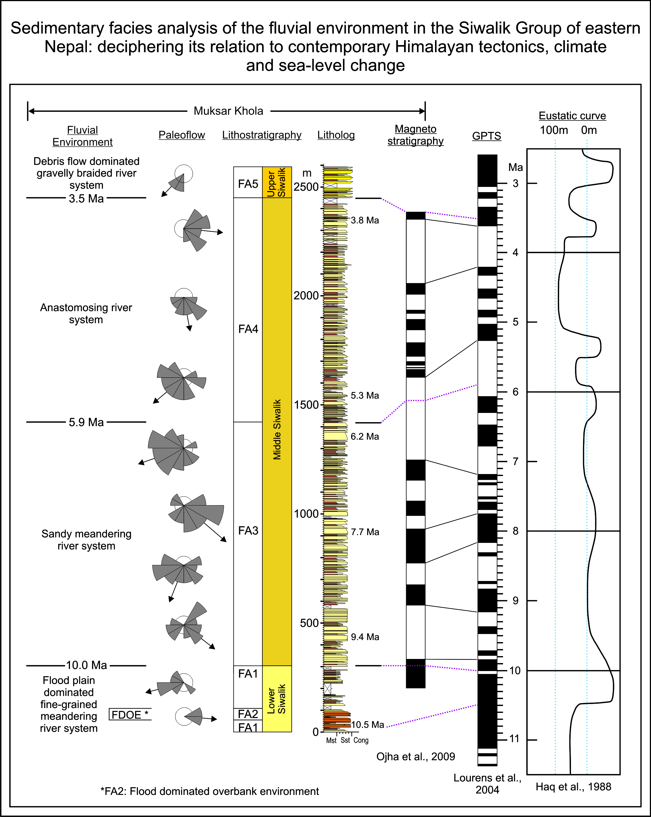
Generally, channel styles are determined by the channel slope and bankfull discharge (Leopold and Wolman, 1957). The slope of the channel is controlled by the tectonics or change in the sea level (Smith and Smith, 1980; Smith, 1986; Burbank, 1992); whereas, discharge is related to tectonics and climate (Goodbred and Kuehl, 2000a; Clift and Giosan, 2014; Clift, 2017). In eastern Nepal, fast exhumation was observed after 11.0 Ma. Similarly, the eustatic curve by Haq et al. (1988) shows the rise in the sea level before 10.5 Ma (Fig. 7). Therefore, the low slope angle due to sea-level rise and absence of the hinterland exhumation must be the reason for the meandering river system before 10.5 Ma.
During the deposition of the lower member of the Middle Siwalik sub-group, fast exhumation was observed in the eastern Nepal Himalaya similar to its western and central counterpart. This exhumation of the hinterland could have increased the channel slope angle and sediment supply resulting in a domination of the braided river system similar to western and central Nepal. The evolution of the braided river system in western and central Nepal has a similar trend with hinterland exhumation i.e. around 9.5 Ma in the Karnali River section and 6.5 Ma in the Surai Khola section (Table: 3). But, the tectonic history of eastern Nepal is quite different from central and western Nepal. In western and the central Nepal Himalaya, observed fast exhumation of the hinterland was due to the formation of the duplex structure which began at 12 − 10 Ma and 9.8 Ma respectively (Huyghe et al., 2001; Robinson et al., 2003; Herman et al., 2010). In the eastern Nepal Himalaya, such a duplex structure was developed only after 4.0 Ma (Haviv et al., 2009; Rai et al., in press). The tectonic activity of hinterland during the deposition time of the lower member of the Middle Siwalik sub-group was the activation of the Sun Koshi Thrust (Schelling and Arita, 1991; Rai et al., in press). Therefore, the possible explanation may be asymmetric subsidence (Burbank, 1992) of the foreland basin in eastern Nepal Himalaya. According to Burbank (1992), if thrusting is the primary cause of mountain uplift, the resultant crustal thickening causes more subsidence and deposition in the proximal parts of the foreland resulting in the restriction of the fan to the proximal area. Contrary to this if enhanced erosion is the cause, then flexural uplift occurs across the foreland basin due to isostatic adjustment which displaces sediments to a more distal part of the basin. The imbrication of thrusts in duplex structure results in regional uplift compared to the single thrust that breaches the surface, enhancing a comparatively high rate of erosion. Robinson et al. (2001) also mention the absence of duplex structure resulted in less erosional unroofing in eastern Nepal Himalaya compared to western and central Nepal Himalaya. Therefore, the activation of the out-of-sequence thrust and absence of duplex structure in eastern Nepal Himalaya could have resulted in this asymmetric subsidence and lead more sediments to be trapped in the proximal part of the basin, resulting in the starvation of sediments at the distal part where the present lower member of the Middle Siwalik sub-group was deposited.
Despite this, the occasional episodic occurrence of a very thick succession of amalgamated sandstone beds in limited thickness within the sandy meandering river system (FA3) at ca. 9.4 Ma, 7.7 Ma and 6.2 Ma suggests some change in the fluvial condition. Sandstone amalgamation usually occurs in the central region of the channel suggesting a high rate of flow energy, deposition and erosive capacity (Zhang et al., 2017). The sub-angular to angular elongated mud clasts (up to 20–30 cm in length) that are observed on the base of the amalgamated sandstone (Fig. 6-E) suggest the erosive nature of flow and give evidence of flooding as discussed above. Other than this, the timing of the occurrence of these thick succession of amalgamated sandstone succession in the present study is coeval to the timing of sea-level fall and rise (Fig. 7). The eustatic curve of Haq et al. (1988) shows a change in the sea level around 10.5 Ma, 8.7 Ma, 6.6 Ma, 5.5 Ma and 3.8 Ma. Therefore, the occasional occurrence of this very thick succession of the amalgamated sandstone should be the result of the interplay of high discharge and sea-level rise. The absence of evidence related to river incision as discussed above during the sea-level fall may be either due to the rate of sea-level fall or the shift of depositional area. If we see the eustatic curve (Fig. 7), the rate of sea-level fall around 8.4 Ma and 6.4 Ma is not sudden and on a large scale as observed around 10.5 Ma. Also, the dominating grain size of Facies 3 is medium- to coarse-grained sandstone suggesting depositional area somewhere upstream to the depositional area of Facies 1, suggesting a shift of the depositional area more proximal to the hinterland.
Anastomosing of rivers are controlled by both climatic and geological conditions where anabranching of new channels are mainly due to the avulsion process (Nanson and Knighton, 1996; Makaske, 2001). The frequency of avulsion increases with an increase in sedimentation rate (Bridge and Leeder, 1979; Bryant et al., 1995) and base-level rise (Tornqvist, 1994; Makaske, 2001). The rise of the base level may be due to the rise in the sea level (Smith and Smith, 1980) and the subsidence of the foreland basin (Smith 1986). The subsidence of the foreland basin and rise in the sea level during the deposition of the upper member of the Middle Siwalik sub-group (Fig. 7) fulfils the condition of base-level rise. Furthermore, an increase in seasonality observed by the shift of C3 plants to C4 plants can be considered another contributing factor. Increasing seasonality suggests strengthened monsoon (Quade et al., 1989; 1995) and an arid to semi-arid climatic condition where bankfull discharge exceeds rarely more than once a year (Gibling et al., 1998). Such bankfull discharge occurs during the high magnitude floods triggered by a strengthened monsoon. During a normal time of such conditions, deposition of the sediments takes place in-channel, consequently, the channel loses the capacity to accommodate sediments in the next flood and become liable to avulsion (Makaske, 2001). Various researchers also suggested the avulsion process takes place during a large flood (Like Brizga and Finlayson, 1990; Mack and Leeder, 1998).
The eustatic curve after 6.0 Ma mainly shows three falls and a rise of the sea level (Fi. 7). Considering our previous discussion this effect of sea-level change should have brought some change in the lithology, but such distinct lithological changes are absent. The probable consideration might be the shift of the depositional area more proximal to the hinterland. The sea-level rise resulted in an overall rise of the base level of the foreland basin, but the deposition area was far from the sea. Therefore, it was more controlled by the hinterland tectonics and climate. Due to this the small changes in the sea level was overprint and was not traced on the lithology of the upper member of the Middle Siwalik sub-group. This shift of the depositional basin towards the hinterland concerning the depositional age suggests the foreland basin was continuously drifted north towards the hinterland.
5.3 Significance of thick mudstone beds in Upper Siwalik sub-group
The gravelly braided river system marked by the abrupt increase in the grain size to gravel size in the Upper Siwalik sub-group indicates a shift of the depositional basins more proximal to the hinterland. The composition of the conglomerate suggests the supply of the gravels mainly from the Ramechap and Tumlingtar Group of the Lesser Himalaya Series. Very thick beds of sandstone (ca. 3 m) and mudstone (˃4.0 m) observed associated with a conglomerate in the present study area is quite unusual, since studies along the Siwalik section in central and western Nepal, mention absence or very limited thickness of sandstone and mudstone beds associated with such conglomerate (Nakayama and Ulak, 1999; Ulak and Nakayama, 2001; Sigdel and Sakai, 2016). Generally, debris flows are more common in inner alluvial fan (Blair and McPherson, 1994; Miall, 2006) where boulder conglomerate are reported in both paleo and modern fluvial system (Singh et al., 1993; Nakayama and Ulak, 1999; Ulak and Nakayama, 2001; Miall, 2006; Sigdel and Sakai, 2016). The absence of boulder size clast (where the size of clast hardly reaches cobble size) in the present study reveals either presence of a small alluvial fans or long-distance travel of debris flow. If we see the modern river system in the foothill of the Himalaya many small and medium rivers exist in between big river system. Willis (1993b) suggested the idea of small rivers in the fan and interfan areas that drains local area. Therefore one possibility is the existence of a similar environment where small river fans exist and share a common or proximal basin during the deposition of FA5.
On the other hand, such progradation of gravels was reported in the Nalad Khad and Jawalamukhi section of the Himachal Pradesh (Brozovic and Burbank, 2000). Brozovic and Burbank (2000) suggested three hypothesises for such progradation of gravels. (1) Increase in the discharge and sediment flux of rivers due to climate change, (2) Initiation of the Main Boundary thrust led to significant erosional relief developing above it and (3) Decrease in the subsidence rates of the foreland basin due to gradual hinterland erosion without major tectonism. If we consider increase in the seasonality resulting in a strong monsoon as a factor for high discharge and sediment flux in the present study, then similar lithology should have been observed in the central Nepal Siwalik section, since the timing of monsoon intensification and vegetation change at the present study area and central Nepal are coeval. Therefore, the presence of gravel progradation only in the present study area denies the possibility of climate change as the controlling factor. In eastern Nepal, the activation of the MBT at the frontal margin of the Himalaya already started around 5.5 Ma (Ojha et al., 2009; Rai et al., in press), but activation of the duplex structure at the rear of the Himalaya after 4.0 Ma should have slowed down the movement of the MBT. Hence decrease in the movement of the MBT should have consequently reduced the subsidence rate. Therefore, either existence of the small alluvial fans or a decrease in the subsidence rate of the foreland basin may be the reason for the gravel progradation in the present study area.