HST dataset
The HST images displayed in Figure 1, 3, S1 and S5 (except for Figures 3a and S5a) correspond to STIS long exposures acquired either with the 25MAMA clear filter or the SrF2 one, using the time-tag mode and processed as described in past published studies11. The STIS images were calibrated through the Space Telescope Science Institute pipeline. A model planetary disc was adjusted to the solar reflected emission to retrieve accurate pixel coordinates in a physical frame (and fix any pointing error). They were corrected for any geocoronal contamination throughout the detector, by subtracting a uniform offset intensity derived on the sky, well beyond the disc. A background model of solar emissions reflected by the disc was then fitted to and subtracted from each individual image. We used two kinds of background model. When the number of images collected during a given HST campaign was large enough (as in 2011, 2012, 2020 and 2022), we used as an empirical model the median of the other images using the same filter, once rescaled at the same apparent size. This also accounts for atmospheric emissions extending beyond the limb. When the statistics of images was too low and/or intense extended auroral emissions could contaminate the median background (as in 2014 and 2017), we built up instead a numerical disc model from fitting the 2-D brightness distribution with a 1st order Minnaert function34 over 30° wide bands in latitude, complemented, outside the disc, by an exponentially decreasing brightness profile. In practice, an empirical model provides a more realistic but noisier estimate of the disc background. The background-subtracted images were then converted into kilo-Rayleighs of unabsorbed H2 emission with standard conversion factors35 and ultimately smoothed over a 5×5 pixels averaging filter to increase the signal-to-noise ratio (SNR), while preserving spatial resolution. Figures 3a and S5a show an HST image obtained with another FUV spectro-imager, the Advanced Camera for Surveys (ACS), which was used here with the F125LP filter comparable to the 25MAMA one. This image of the first reported auroral detection with ACS so far (this instrument has been regularly used in 2005, 2011 and 2012), has been processed in exactly the same way with an empirical model of disc background. It is worth mentioning here that, as for the weak auroral detection obtained with STIS in 2012, the northern auroral signal observed by ACS was seen to rotate with the planet in the sub-exposures of this observation. HST processed observations of Uranus are also directly accessible through the APIS service36.
Model auroral ovals
The model auroral ovals employed in this study correspond to the footprints at 1100 km above the 1 bar level (where the electrons are assumed to trigger the aurorae) of magnetic field lines with M-shells = 5 RU and20 RU. This altitude was transposed from the Saturn’s case whose atmospheric profile is comparable, under the assumption that Uranian auroral electrons are not more energetic12. The 5 RU and20 RU magnetic shells were chosen as, respectively, a typical low-latitude edge of the UV aurorae observed by UVS9, and a typical standoff distance of the magnetopause3. The associated magnetic shells thus encompass most of the magnetosphere. Northern and southern model auroral ovals were derived for both the AH5 internal field model– as already done to fit the magnetic poles from the aurorae detected in 2012, 201412 and 20176 – and the Q3 model for comparison purposes. We chose to limit ourselves to internal field models rather than magnetospheric ones9,13 for simplicity. Deriving a more realistic magnetospheric model accounting for the compression of the magnetosphere by the solar wind would require to precisely know the solar wind parameters prevailing during the HST observations, which is beyond the current state of the art since the observations were scheduled on purpose during intervals encompassing strongly variable solar wind, whose parameters were additionally predicted with a ±2 days uncertainty11. More importantly, using a magnetospheric model would not significantly change the low latitude boundary of model ovals as the M-shell = 5 RU is located in the inner magnetosphere shielded from the solar wind9. This is particularly striking for the fit of images where northern and southern aurorae were observed simultaneously, as for the 2017 and 2022 images in Figure 1.
While the auroral emissions were fitted with model auroral ovals defined from the multipolar Q3 and AH5 internal field models, the observable used in our analysis is the longitude of the magnetic poles defined for the Offset/Tilted Dipole (OTD) model. The link between model ovals and the longitude of the OTD magnetic poles is illustrated in Figure S4, which shows Uranus as seen from from Voyager 2 at CA. The AH5 (left-hand side) and Q3 (right-hand side) southern model ovals are displayed by pairs of solid lines. While they slightly differ from each other, they both correspond to the same OTD southern magnetic pole which lies at the intersection of the red dotted-dashed meridian (longitude) and the red dashed parallel (latitude).
Auroral fitting and χ2 analysis
Table 1 provides the IAU17.24h longitude of the OTD northern magnetic pole (which can be deduced from the southern one whenever not observed) for the six chosen reference HST images displayed in Figure 1. This longitude was obtained from the best-fit of the Q3 and AH5 model ovals and accompanied by an error bar (within parenthesis) obtained from the most extreme fits of the same ovals. Figure S2 illustrates this fitting procedure with the example of Q3 model ovals applied to two representative images, one poorly constrained in 2011 and one strong constrained in 2022. Indeed, the former restricts to a single, localized, northern auroral spot, while the latter displayed elongated auroral emissions observed simultaneously in both hemispheres well beyond the limb. The uncertainty on the longitude of the best-fit ovals is +15°/-21° and ±12°, respectively
Unlike a simple least-square fit, the calculation of the χ2 data-model test described in the main text is weighted by the error on data points. Instead of the simple error bars (sometimes asymmetric) provided above, we used their quadratic sum as a typical, more realistic, uncertainty on the best-fit longitudes. Applied to the two examples of Figure S2, this corresponds to error bars of ±26° and ±17°, respectively, wider by a few degrees than the initial estimate but hence more robust. The modeled longitudes were obtained as detailed below.
SIII longitudes
As outlined in the introduction, in the ULS spin-aligned coordinate system used during the Voyager 2 epoch, the rotation axis points toward the north pole. Latitudes are counted positively toward the same direction, so that the northern and southern OTD magnetic poles lie at positive (+15.2°) and negative (-44.2°) latitude, respectively. The Uranus rotation is prograde and longitudes are counted positively westward, so that the CML of a fixed observer increases with time. This longitude system was arbitrarily referenced at CML = 302° at the Voyager 2 CA.
The System III coordinate system referenced by IAU uses different conventions. The north pole is here defined as pointing northward to the ecliptic plane, so that IAU latitudes are opposite to ULS ones and the Uranus rotation is retrograde. IAU planetocentric longitudes are counted positively eastward, whatever the sense of planetary rotation, so that the CML of a fixed Uranus observer increases with time. IAU planetographic longitudes use another convention for historical reasons, and are defined as increasing with time whatever the sense of rotation. In the case of Uranus, both uranocentric and uranographic longitudes thus coincide.
The IAU sub-observer planetocentric latitude δ and longitude ω are provided by the following set of equations14 :
- sin δ = - sin δ0 sin δP - cos δ0 cos δP cos(αP - α0)
- cos (W-ω) cos δ = - sin δ0 sin δP - cos δ0 cos δP sin(αP - α0)
- sin (W-ω) cos δ = - cos δ0 sin δP + sin δ0 cos δP cos(αP - α0)
where (αP,δP) are the equatorial apparent coordinates of Uranus center of mass, (α0,δ0) those of the north pole direction and W is the angle defining the position of the prime meridian in the Uranus equatorial plane according to the equation :
W = W0 + W1d
where W0 is the position of the prime meridian referenced to the intersection by the equatorial plane and the celestial equator at the J2000 epoch (JD 2451545.0 = 2000 January 1 12.0 h TDB), W1 is the SIII rotation period in degrees per day and d is the time interval between the observing time and the J2000 epoch. The numerical values of (α0,δ0), W0 and W1 were chosen from the latest report of the IAU working Group on cartographic coordinates and rotational elements2 (see their Figure 1 for a visual representation of these angles) and those of (αP,δP) were obtained at mid-exposure for each observation from the IMCCE/MIRIADE ephemeris service.
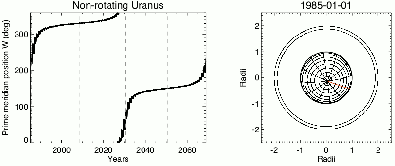
Animation S6 illustrates that the proper motion of Uranus along its orbit is non negligible near solstice periods and/or for long enough intervals. It displays the position of the prime meridian and the planetary configuration as seen from Earth as a function of time for a non-rotating Uranus (W1 = 0).
For our purpose, we first checked that we retrieved IAU longitudes from the above set of equations consistent with those provided by IMCCE/MIRIADE (planetocentric longitudes by default) and by the JPL Horizons ephemeris (planetographic longitudes by default). We then computed model SIII longitudes by varying W1, that is the rotation period.
The IMCCE/MIRIADE online ephemeris service can already be used with the new 17.247864h rotation period obtained in this article to in turn provide IAUnew corrected longitudes. The new CML at mid-exposure associated with the images displayed in Figure 3 are listed in Table 2.