2.1) Rift setting and survey area
The Mohns and Knipovich Ridges form the northern extension of the Mid-Atlantic Ridge (MAR) and ensure the continuity between the MAR and the Gakkel Ridge. Their junction is associated with a 70° bend in the ridge axis orientation.
This peculiar spreading ridge configuration is highlighted on the bathymetry(11) and associated ruggedness analysis(12) (Fig. 1a, b). Within the Knipovich Ridge, the axial rift valley shows an "en echelon" system including NNE-trending troughs, approximately 3.5-4 km deep. South of 74°47'N, the strike of these rift troughs becomes progressively N30°E oriented and gradually approaches that of the rift valley (N20°E), in the southern Mohns Ridge segment.
Between the Mohns and Knipovich Ridges, the western slope of the rift valley presents fault benches covered with sediments as thick as 1 km, however seismic and dredging data reveal that the steep slopes are devoid of sediments and made of basaltic pillow lava(13). The eastern flank of the axial rift valley (rising 500–1000 m above the ridge axis) is considerably lower compared to the western slope (rising 1000–2000 m above the ridge axis), witnessing a spreading asymmetry. West of the rift valley, linear elevated ridges progressively turn from a N30°E orientation to the South to a N10°W orientation to the North. Regional bathymetry also reveals a series of prominent features topping at 600 m below sea level to the Northwest of the ridges junction. The various highs are bordered by steep escarpments showing high ruggedness indexes (Fig. 1a, b). North and East of the Mohns Ridge, the main structural highs pass into the deep structures of the Knipovich Ridge. There occurs a system of wide benches separated by low scarps plunging towards the bending rift valley.
Approximately 25 km southwest of the bending rift valley lies the high-temperature hydrothermal site Loki’s Castle (Fig. 1a, 2a). The site stands at 2,350 m depth and is made of two roughly circular mounds, 150–200 m width, actively venting fluids at 310–320°C(9). As part of the MarMine oceanographic campaign, this site was investigated by R/V Polar King in 2016(14). The ship deployed the Autonomous Underwater Vehicle (AUV) Hugin, which carried out a dive over the hydrothermal site to collect high-resolution bathymetric and magnetic data. The near-seafloor magnetic data were acquired by a fluxgate magnetometer from Ocean Floor Geophysics mounted to the AUV(15) (Methods and Supplementary Information). The AUV routes were 150 m apart and 100 m above the seafloor (Fig. 2b, c, d).
Airborne aeromagnetic data were also collected in 2016 and 2018, as part of the Norwegian Geological Survey efforts to investigate the oceanic domain west of Svalbard and the western Barents Sea margin(16, 17). The airborne data were acquired at 120 m above sea level and with a line spacing of 5500 m. The survey area extends 120 km in NW-SE and 150 km in SW-NE. It encompasses the eastern end the Mohns Ridge, the southern part of the Knipovich Ridge and the bend marking their junction (Fig. 3a).
2.2) Magnetic Exploration Of The Ridges Junction
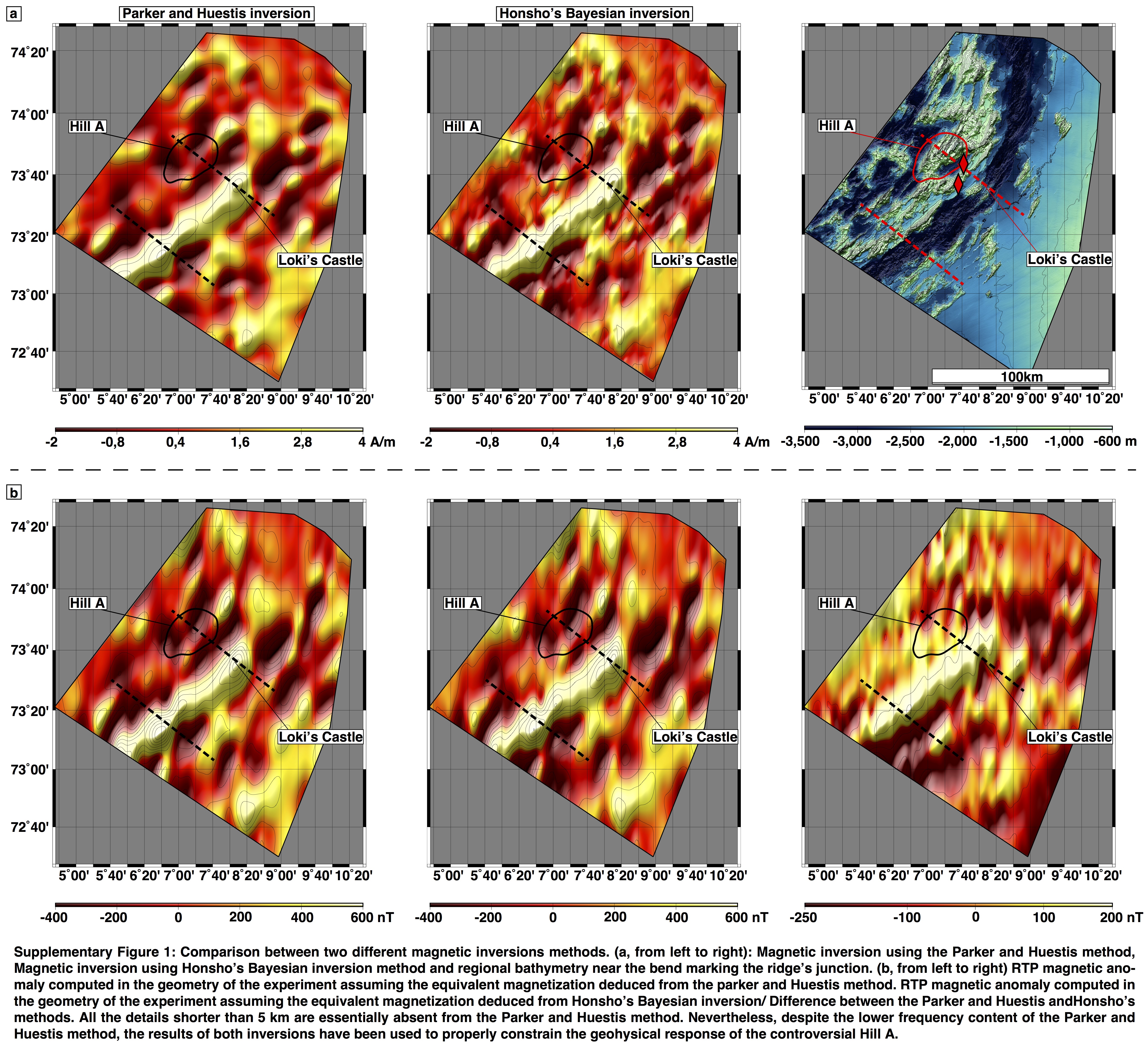
The near-seafloor magnetic data reveal a significant drop in the equivalent magnetization while the AUV passes between the hydrothermal mounds (Fig. 2a, b). Logically, the RTP magnetic anomaly and the vertical derivative also indicate that the site is associated with a negative RTP magnetic anomaly, confirming previous studies and proving that this hydrothermal site sits on a basaltic substratum(9) (Fig. 2c, d).
Regional magnetic data display long-wavelength magnetic anomalies corresponding, among others, to the inversions of the geomagnetic field polarity. The amplitude of these anomalies decreases while moving away from the spreading axis, as the basalt gets progressively altered by seawater circulation. The off-axis bathymetric Hill A is located on both sides of the Gauss-Gilbert geomagnetic polarity reversal, and is therefore associated with a magnetization switching from positive to negative polarities while moving off axis. Unsurprisingly, the prominent Hill A induces a magnetic anomaly with a higher amplitude than the surroundings (Fig. 3).
2.3) Observations
Oceanic Core Complexes exclusively form along slow and ultraslow-spreading centers, i.e., in dominantly tectonic environments(7, 18, 19), and preferentially develop near the end of ridge segments(8). In their strict definition, these structures correspond to oceanic massifs constituted by mafic plutons and/or ultramafic mantle rocks that exhume on the seafloor, at the footwall of low-angle detachments(20).
As imaged by seismic data, OCCs detachment faults show gentle and smooth convex upward profile(21, 22) and often develop corrugated dome-like structures with striations parallel to the displacement direction(21–23). Meanwhile, the hanging wall of the detachment often corresponds to graben-type structures, including a conjugate pattern of steep normal faults(8, 24). Deformation of the footwall rocks in the detachment zone is localized within a narrow shear zone (< 200 m)(25). During the spreading, the space created by footwall rotation is progressively accommodated by addition of hot viscous magmas at the root of the detachment and/or flow of the ductile mantle(25). On the basis of observations and modelling, a rolling hinge mechanism involving progressive unroofing and denudation of the mantle has been widely accepted for the development of OCCs(26).
Being a slow-spreading center, the Mohns Ridge could constitute a preferential area for the development of such mantle exposures, particularly near its junction with the Knipovich Ridge. As a result, the prominent Hill A located 30 km to the Northwest of the ridge axis was previously classified as an OCC(27, 28) (Fig. 1a). The main argument for an OCC interpretation was the collection of two rock samples containing gabbros and serpentinites in its surroundings(9, 29, 30). Nevertheless, bathymetric and magnetic observations suggest that despite the presence of these rocks, this bathymetric high does not match the characteristics of true OCCs.
The presence of serpentinites near the end of slow-spreading segments is common(8), but does not necessarily imply the existence of OCCs(5, 6, 31). The recovered mafic grab-samples do not come from the controversial hill, but were instead collected either between the neovolcanic zone and its foot or on another hill, located 25 km further south(29) (Fig. 3a). These rocks therefore do not address the question of the hill geology, and do not confirm the presence of a mafic massif on its top.
Compared to confirmed OCCs, the Hill A does not clearly show any smooth and corrugated morphology, as expected in response to a rolling hinge denudation of potential mantle rocks. The seafloor ruggedness instead suggests the presence of numerous and widely distributed steep normal faults from the rift valley up to the elevated flanking terrain. Despite a marked prominence, the bathymetry underlines that the structural style does not differ from the surrounding basaltic seafloor (Fig. 3b).
To obtain a quantitative support, we considered and modeled two magmato-tectonic scenarios:
-
The Hill A is dominantly basaltic. This scenario aligns with the off-axis basaltic seafloor confirmed from the high-resolution magnetic data collected over hydrothermal site Loki’s Castle. Assuming this hypothesis, the average magnetization of the rock constituting the hill should be consistent with the surrounding basaltic seafloor at a comparable distance from the spreading axis. In this context, the few recovered rock samples would originate from small mantle pocket exposures typically found near the end of ridge segments(32). We compare the data along Profile 1 with another profile (Profile 2) located further southwest, where no mantle rocks exposure has been found. The quantification and removal of the hill’s magnetic footprint confirm that the seafloor along both profiles have comparable magnetic signatures (Methods) and should be of similar geology (i.e., basaltic) (Fig. 3b).
-
The Hill A is dominantly ultramafic. Such alternative scenario would support the existence of an OCC. With such a crustal configuration, we would expect the rock absolute magnetization on top of the hill to be approximately five times weaker than that of the basalt(33, 34). Under these constraints, preserving the observed RTP magnetic anomaly amplitude implies an accumulation of magnetized material considerably more important than for a basaltic layer. It would require an unrealistically tall bathymetric feature, which is inconsistent with present-day observations and the inversion results (Methods).
The formation of OCCs is usually associated with a marked asymmetry in the regional magnetic anomalies, as the spreading essentially occurs on one side of the ridge axis(35). However, no significant asymmetry in the geomagnetic polarity reversals is observed(16) in the vicinity of Mohns and Knipovich Ridges junction and no evidence suggests that the spreading occurred exclusively on the northwestern side of the spreading axis (Fig. 3a). The regional magnetic anomalies and the modeling support our idea and suggest that no major unroofing from the deep crust and upper mantle denudation is at play.