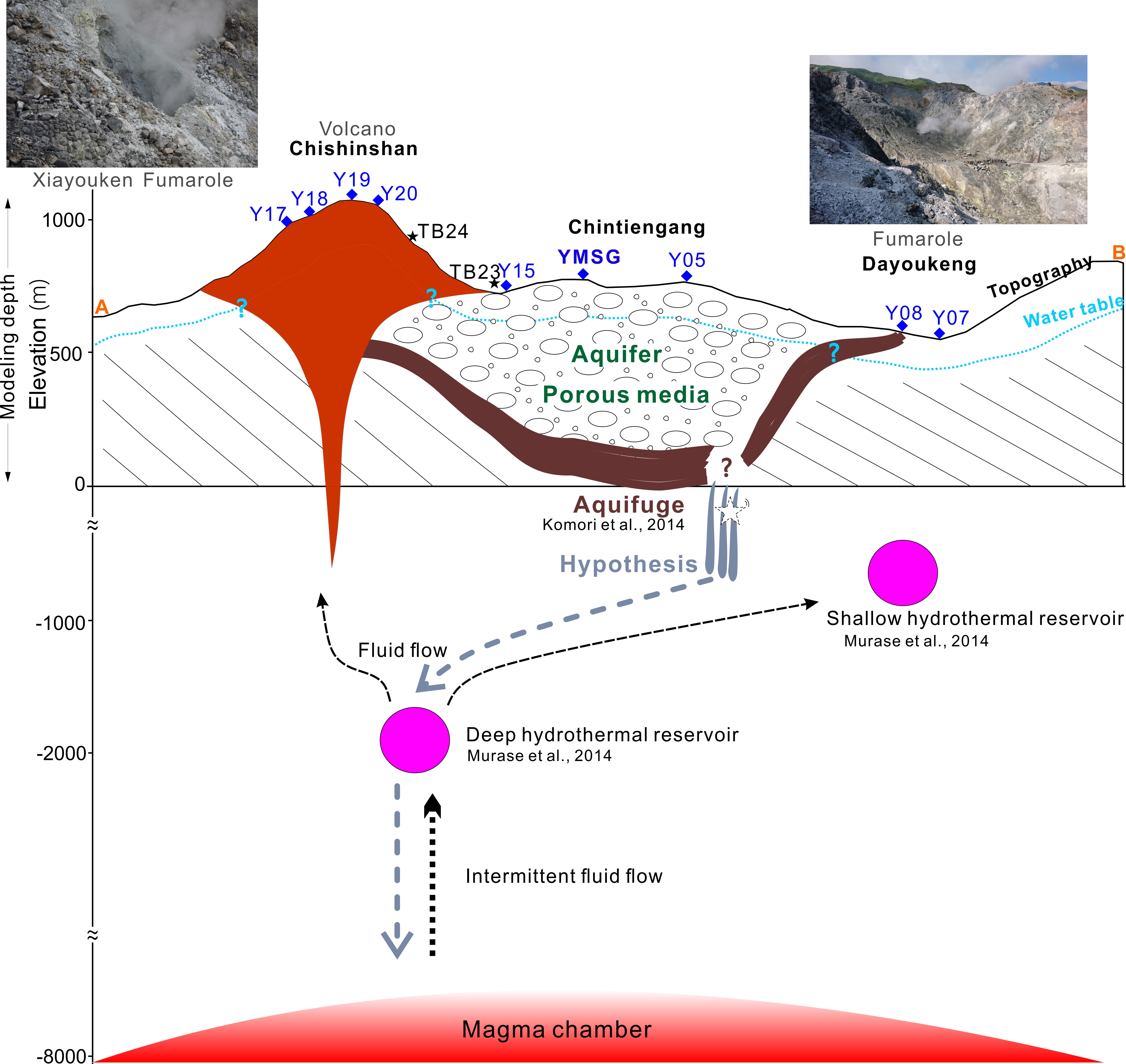
The Tatun Volcano Group (TVG) is located in northern Taiwan and originated from the active plate convergence in the western Pacific ring of fires. Because the TVG neighbors Taipei City and New Taipei City, its eruption will threaten the lives of about 7 million people in the two cities, and potentially damage the two nuclear power plants at the northern flanks of the TVG, creating major economic and social crises in Taiwan (Konstantinou, 2015). The latest phreatic eruptions of the TVG occurred about 6000 years ago (Belousov et al., 2010). Recent studies have shown that the TVG is a potentially active volcano (Lin et al., 2005b; Murase et al., 2014). Data from a new seismic network (Pu et al., 2014) over the TVG showed repeated occurrences of local seismic swarms associated with fluid migrations. In addition, Lin (2016, 2020) detected magma chambers below the TVG using the seismic S-wave shadows and P-waves delay. Hydrothermal reservoirs in the eastern limb of the TVG (Fig. 1a) have been detected using volcano-earthquake signals (Lin et al., 2005b), precise leveling survey (Murase et al., 2014), audio-magnetotellurics (AMT; Komori et al., 2014). The variations of fumarolic gas compositions indicated highly hydrothermal activity below the TVG (Lee et al., 2008).
Gravity observations have been used to assess the states of volcanoes around the world. For example, Rymer and Brown (1989) used time-lapse gravity changes as a precursor, on the ground that ascending magma before an eruption can lead to mass changes. Using gravimetric and geodetic measurements, Battaglia et al. (2006) showed that the fluid migration in the Campi Flegrei caldera hydrothermal system was the cause of ground deformation and geological unrest. Kazama et al. (2015) showed that gravity changes can originate from both magma and non-magma sources. Depending on the location, the largest contributor of gravity change around a volcano can be hydrological variation, which can overwhelm magma-induced gravity changes around a volcano by many orders of magnitude. Using the absolute gravity measurements in 2004–2007 around the TVG, Mouyen et al. (2016) suggested the existence of a tube-like structure that allows a large-scaled hydrothermal fluid circulation below the TVG.
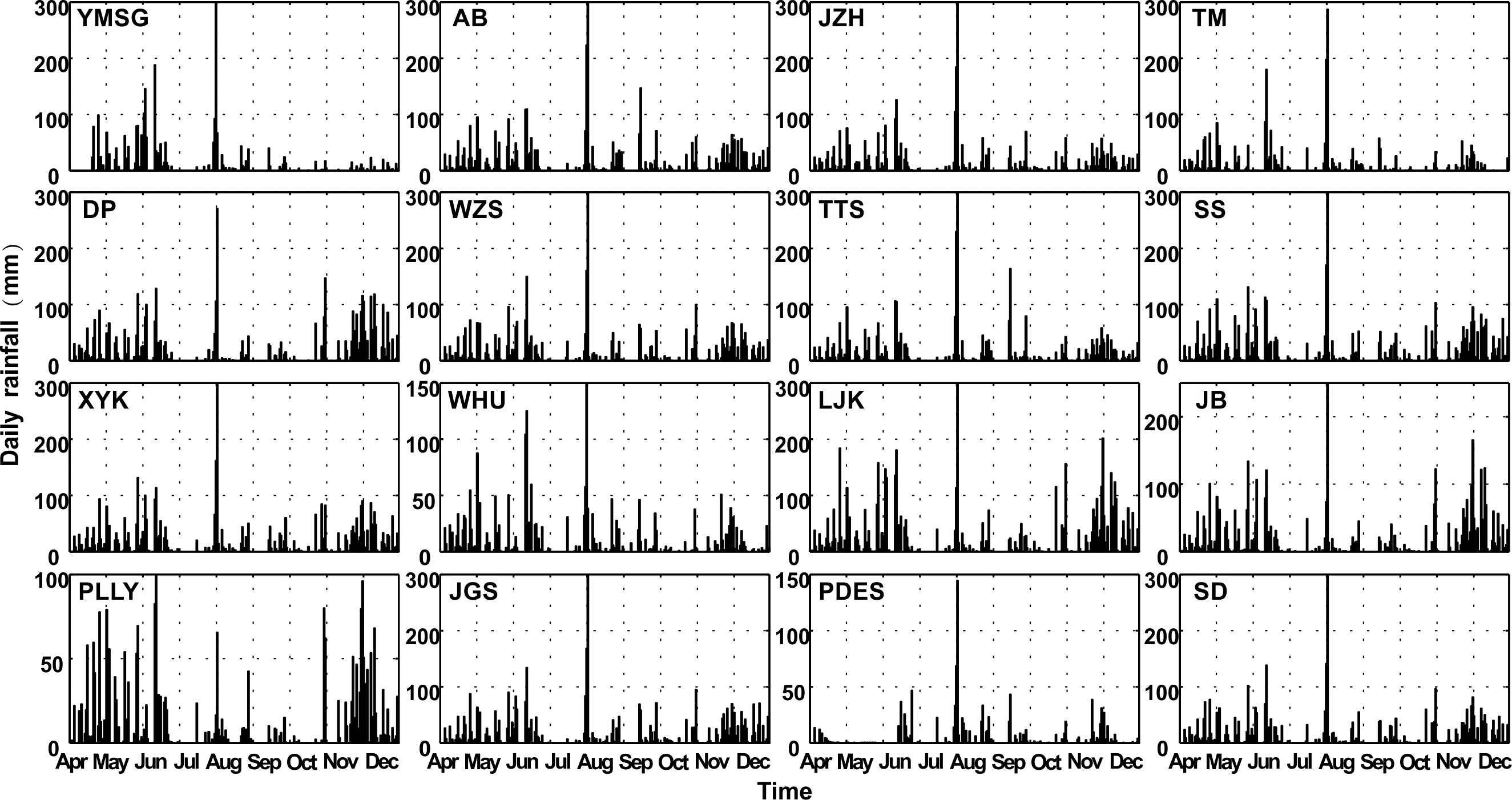
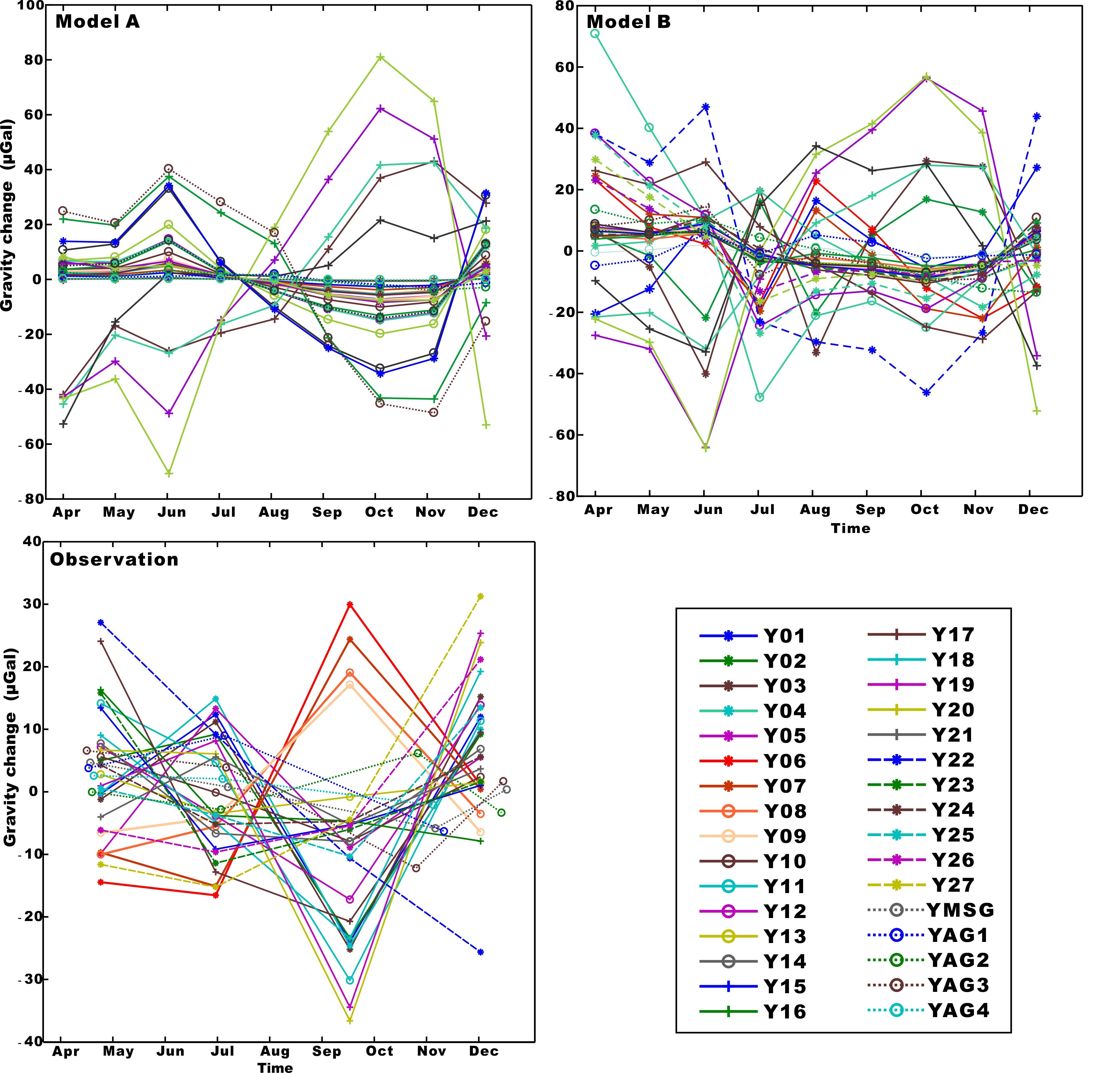
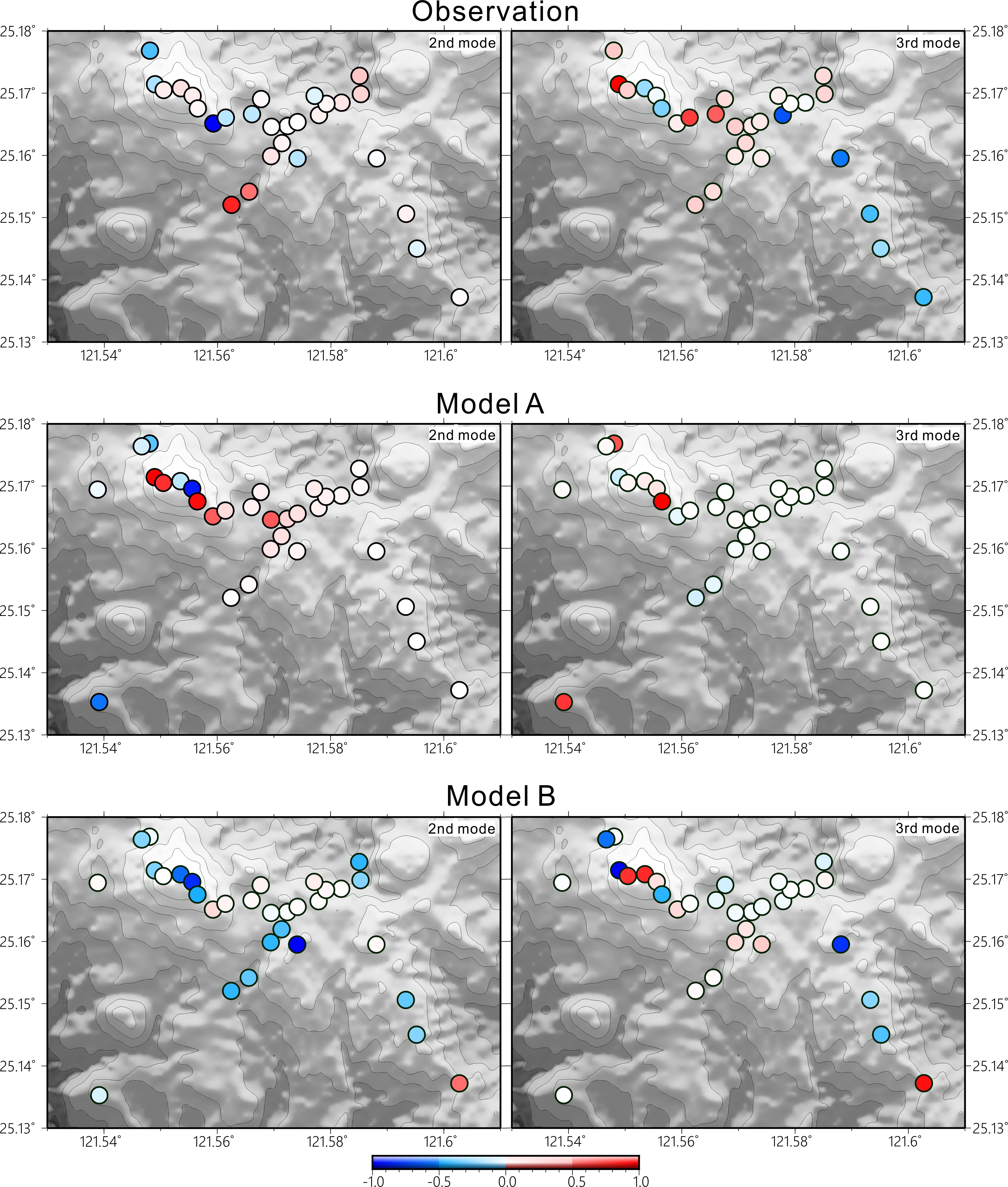
A gravity-based study of the TVG began with the installation of an AG site at a continuous GPS station, called YMSG, in the TVG in 2004 (Kao et al., 2017). In 2012, a superconducting gravimeter (SG, serial number T49) was installed at YMSG. Prior to 2012, 4 new absolute gravity sites and 27 relative gravity sites along 5 hiking trails of the TVG were constructed (Fig. 1a). In 2012, four gravity surveys were carried out and the surveys covered the approximate volcanic regime of the TVG, including Chihsinshan, Chintiengang, Dayoukeng and Dingshan in an area of about 10 km2 (Fig. 1a). In the gravity surveys, one absolute gravimeter (AG) and two relative gravimeters (RG) were also used. In contrast to the continuous, one-second measurements by the SG/T49 meter, the gravity measurements by the AG and RG meters are time-lapsed with a 3-month measuring interval.
In most gravity studies of volcanoes, gravity effects originating from hydrological changes are estimated by models that do not consider 3-D flows of groundwater, which are largely affected by local hydrogeological settings. In principle, a 3-D hydrological model of an aquifer below a volcano is able to show how groundwater transports, as in an alluvial plain (Singhal and Gupta, 2010). However, over a volcano the hydraulic conductivities of volcanic materials can vary widely, at a range of nine orders of magnitude. For example, the hydraulic conductivities of lava flows and cinder beds are high and those of ash beds, intrusive dikes and sills are much lower (Fetter, 2001). Thus, validating a 3-D model for groundwater flows over a volcanic region can be challenging.
Gravity changes can be a type of data for validating a 3-D groundwater flow model because a gravimeter can sense mass changes due to groundwater re-distributions from the model. An example in Taiwan is the investigation of the active state of the Hsinchu Fault using gravity changes from a superconducting gravimeter (Lien et al., 2014). In the TVG, the sources of gravity changes are seasonal hydrological changes, transitional fluid migrations (Mouyen et al., 2016) and secular plate motions (Kao et al., 2017). In typical solid earth applications of gravimetry, gravity changes of hydrological origins (called the hydrological gravity effect) are regarded as noises and are removed from the raw gravity measurements before solid-earth applications. At a gravity site, the hydrological gravity effect is the sum of the effects over the unsaturated zone and the saturated zone below the site. Typically, the effect from the unsaturated zone is determined and removed using soil moisture measurements and the methods for this effect can vary widely, from the simple Bouguer plate model (Torge, 1989) to a sophisticated approach such as those presented by Crossley et al. (1998) and Kazama et al. (2015). Likewise, the gravity effect from the saturated zone can be modeled by a simple model such as Bouguer model (Torge, 1989) or a 3-D model such as the method for the Hsinchu superconducting gravity station (Lien et al., 2014).
In this study, the hydrological gravity effects from the unsaturated zone in the TVG will be still regarded as noises and removed. However, the effects from the saturated zone will be modeled by two approaches that are more comprehensive in 3-D extent than the Bouguer plate model. Such modeled gravity effects are then compared with the observed gravity changes from the four gravity surveys in 2012 to infer the potential boundaries of an aquifer around the TVG. In the following development, we will describe in detail how our gravity measurements were collected and processed, and how two groundwater flow models are constructed to model gravity changes for inferring the aquifer boundaries. Because groundwater flow is important for understanding volcanic unrests (Jasim et al., 2018), this result from this study will benefit the understanding of the aquifer distribution in the TVG for volcanic hazard modeling in northern Taiwan.