Since the 20th century, several large (M ~ 7 or larger) earthquakes have occurred in the Sea of Japan (Fig. 1) that caused damage due to seismic ground motion and tsunamis on the coast (Earthquake Research Committee (ERC) 1999). These earthquakes were analyzed using seismic and tsunami data to estimate the source region and fault parameters.
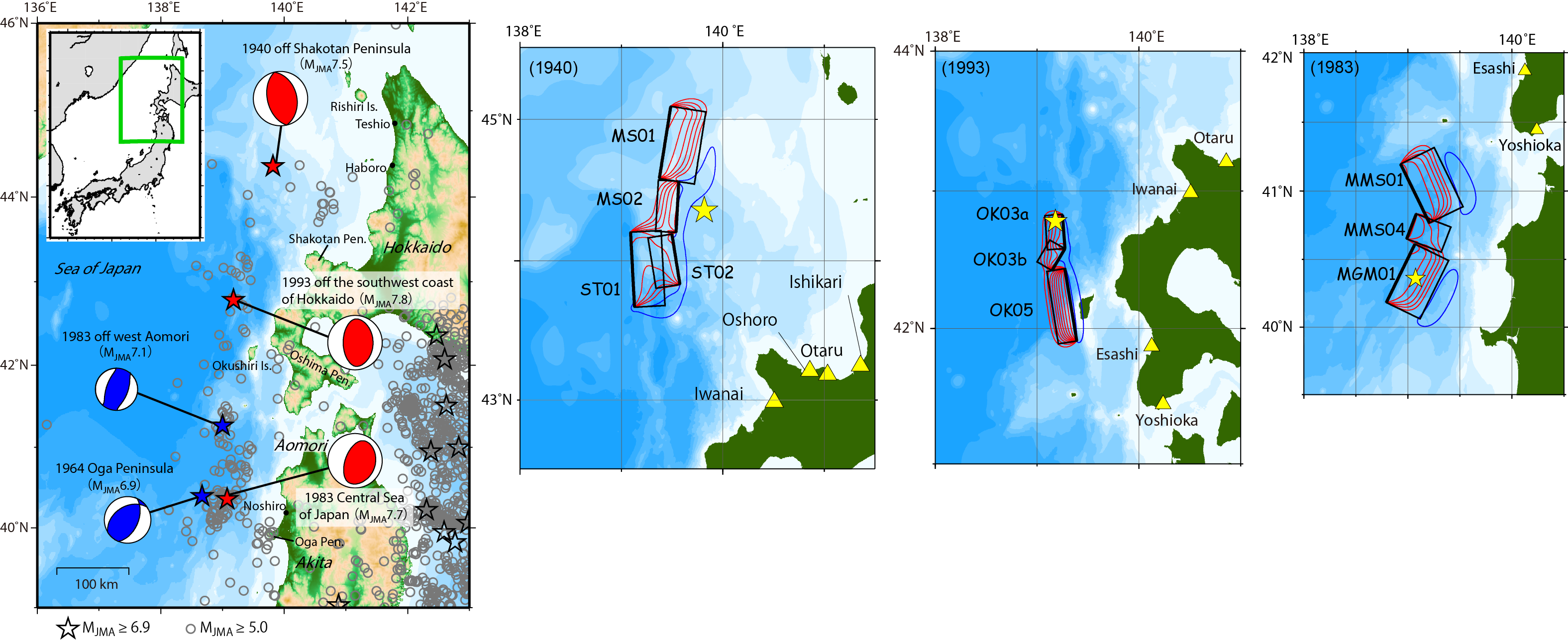
Off Hokkaido, the 1940 off Shakotan Peninsula earthquake (MJMA 7.5) (also called Shakotan-hanto-oki, off the Cape of Kamui, or off the coast of Kamui) occurred and caused a tsunami. There was little damage from the seismic ground motion, but the coastal tsunami height was greater than 2 m at Teshio and Haboro in Hokkaido and Nevelsk in Sakhalin, and there were 10 casualties near the estuary of the Teshio River. The coastal tsunami height on Rishiri Island reached 3 m, and there was light damage to Sado Island and North Korea. In addition, 24 people were injured and 20 houses were washed away by the earthquake and tsunami (Hatori 1969; ERC 2003; Usami et al. 2013).
Various studies on the fault parameters of this earthquake have been documented. Hatori (1969) estimated the tsunami source area from the tsunami travel time data and inverse refraction diagram. Fukao and Furumoto (1975) obtained the focal mechanism solution from the P-wave initial motion, estimated the rupture area from the tsunami source area obtained by Hatori (1969), and calculated the slip amount and seismic moment using long-period surface wave and tsunami data. Satake (1986) revisited the tsunami waveforms, compared the observed waveforms with those calculated by tsunami numerical simulation, and reexamined the fault area, concluding that it was decidedly smaller than that determined by Hatori (1969) and Fukao and Furumoto (1975). Okamura et al. (2005) investigated the fault location from the traces of past earthquakes using seafloor diving surveys, and estimated the fault slip by tsunami waveform inversion. Ohsumi and Fujiwara (2017) compiled fault models based on seismic reflection survey data and validated a suitable model to explain coastal tsunami heights along the Hokkaido coast.
The 1993 off the southwest of Hokkaido earthquake (MJMA 7.8), also known as the 1993 Hokkaido Nansei-oki earthquake, caused the most serious damage along the coast of the Sea of Japan during the 20th century. The coastal tsunami heights reached over 20 m on Okushiri Island and 7–8 m on the west coast of the Oshima Peninsula. The source area of this earthquake was close to Okushiri Island and the west coast of the Oshima Peninsula, and the tsunami struck those regions within 2–5 min. In total, this event caused the death or disappearance of 230 people, with 323 injured, and 601 houses completely destroyed (Hokkaido Tsunami Survey Group 1993; ERC 1999; ERC 2003). Previous studies have analyzed factors relating to this earthquake. Hatori (1994) estimated both the tsunami source area from the tsunami travel times using an inverse refraction diagram and the tsunami magnitude. Tanioka et al. (1995) approximated the fault geometry using seismic waveforms, and obtained the slip distribution from the joint inversion of tsunami and geodetic data. Mendoza and Fukuyama (1996) performed seismic waveform inversion using the strong ground motion data in Japan and teleseismic vertical P-waves, and estimated the slip distribution. Kakehi and Irikura (1997) examined the high-frequency radiation process on the fault plane from the envelope inversion of acceleration seismograms. Takahashi et al. (1994, 1995a, 1995b) investigated the fault model based on the observed coastal tsunami heights and ground deformation using tsunami numerical simulation.
The 1983 Central Sea of Japan earthquake (MJMA 7.7) (also called the Japan Sea earthquake, the Nihonkai-Chubu earthquake, the Akita-oki, and others) struck near the Akita and Aomori Prefectures of the Tohoku region and caused tsunami damage. Its largest aftershock (MJMA 7.1) occurred approximately one month after the mainshock. In the coastal plains of the Aomori and Akita Prefectures, liquefaction damaged structures. The coastal tsunami heights of this earthquake reached 14 m near Noshiro in the Akita Prefecture, 4.3 m on Okushiri Island in Hokkaido, and up to 3 m on the coast of the Chugoku region. As early as 7 min after the earthquake, the tsunami struck the coast near the source area. The damage included 104 casualties (100 caused by the tsunami) with 163 injured, 934 houses completely destroyed, and 52 washed away. The tsunami also caused damage in Korea and Russia (Shuto 1983; ERC 1999; Usami et al. 2013). Hatori (1983) estimated the tsunami source area and the tsunami magnitude. Aida (1984) compared the observed tsunami waveforms with those calculated by tsunami numerical simulation for many fault models and adopted the model that fit the aftershock distribution. Kanamori and Astiz (1985) conducted moment tensor inversion using long-period surface waves and estimated the slip amount on the fault plane, which was inferred from the aftershock distribution. Sato (1985) examined the high-frequency characteristics of the strong motion records and proposed a three-stage rupture process on the fault planes that were estimated from the aftershock distribution. Satake (1985) estimated the focal mechanism solution and fault plane from long-period surface waves, P-wave initial motion, and aftershock distribution, and determined the fault model by a trial and error comparison of the observed tsunami waveforms with those from numerical simulations. Kosuga et al. (1986) assumed the fault plane based on the aftershock distribution and the models of Sato (1985), and then chose the best fault model to explain the tsunami waveform and crustal deformation among certain models with different slip amounts. Fukuyama and Irikura (1986) examined the rupture process using seismic waveform inversion based on the Bayesian approach, which assumed the moment release and rupture start time as unknown parameters. Satake (1989) improved the fault model of Satake (1985) and estimated the slip amount by tsunami waveform inversion using Japanese tide gauge records. For the largest aftershock (MJMA 7.1), Hatori (1984) estimated the tsunami source area and tsunami magnitude. Abe (1987) also estimated the tsunami source area and examined the fault model by conducting tsunami numerical experiments to compare the observed waveforms and travel times with the calculated data.
The 1964 off Oga Peninsula earthquake (MJMA 6.9) occurred near the Akita Prefecture, but its damage along the coast of the Tohoku region was minimal. Small tsunami amplitudes (~ 20 cm) were recorded at the tide gauge stations along the coast of Hokkaido to the Niigata Prefecture (Hatori 1965; ERC 2003; Usami et al. 2013). Hatori (1965) estimated the tsunami source area for this earthquake. Fukao and Furumoto (1975) estimated the seismic moment by comparing the amplitudes of the long-period Love waves from the World-Wide Standardized Seismograph Network (WWSSN) to the synthetic data, and then calculated the slip amount on the fault plane, which was estimated from the aftershock distribution.
Along the eastern margin of the Sea of Japan, many offshore active faults have been investigated, many of which are summarized by Okamura (2019). A government committee jointly supported by the Ministry of Land, Infrastructure, Transport and Tourism (MLIT), the Ministry of Education, Culture, Sports, Science and Technology, and the Cabinet Office of Japan, modeled 60 offshore active faults in the Sea of Japan with the potential to cause large earthquakes, and created a tsunami simulation for each (MLIT, 2014). More recently, the Integrated Research Project on Seismic and Tsunami Hazards around the Sea of Japan (hereafter referred to as the JSPJ: Japan Sea Project) modeled the active faults along the Sea of Japan in detail (JSPJ, 2021) (Fig. 2).
In this study, we examined which active faults that have been modeled by the JSPJ may have caused the 20th century earthquakes. For the 1964 off Oga Peninsula and the 1983 west off Aomori earthquakes, no fault models have been obtained from previous studies. Therefore, we relocated the hypocenters and estimated the fault plane geometries using seismic data, developed teleseismic waveform inversions to obtain the slip distributions, and estimated the fault models. For the above five earthquakes, we conducted tsunami simulations using previous studies or the teleseismic waveform inversion of this study, as well as nearby fault models obtained from the JSPJ, and attempted to identify the causative fault by comparing the calculated tsunami waveforms and the coastal tsunami heights with the observed data.